Day 1 Tuesday, June 15, 2010
We are underway at last. Good travel day. We started at 9:00am after finally finishing the RV loading. Our cats know something is afoot. We relocated their essentials (food, litter box, water) yesterday, so that was their first clue. We are much more comfortable on these trips when someone is taking care of the pets in their surroundings, and living in our home.
We went about 290 miles today, and arrived at the Maryhill State Park (Washington side of the Columbia River) about 3:30pm. It’s a very nice and spacious state park. We have previously been to the Maryhill Museum, and the Stonehenge replica nearby, so we passed on both of those this time.
We used the usual route to Tacoma (305, 3, 16) and headed south on I5. Overcast day, with some sun poking through, but showers in between. Some were very heavy for short periods of time. We headed East on I 205 (WA 14) and then WA 14 for about 40 miles. We crossed the Columbia at a rickety old toll bridge across the Columbia River just above the Bonneville dam. This fascinating old through-truss bridge is called “Bridge of the Gods”. The toll was $2.00 because our RV is dual wheels on the rear axle. We then continued east on I 84, realizing that there was more to explore along the Columbia River sometime in the future. The section of WA 14 before the bridge was beautiful, but winding, and there was road work ahead (at MP54) , so we took I 84. At US 97, we crossed the Columbia River again, and immediately saw signs to Maryhill State Park. By this time, it was a clear, crisp, cool, windy day.
We set up the RV, and were surprised to see another Aspect in the space next to ours. (The RV park sites are in a beautiful, wooded setting, along the Columbia River.)

 The spaces have at least 40-50ft separating them, and the loop around the RV spaces encloses a park -like setting at least 100 yards across. Park is geared toward windsurfing on the Columbia, as there is a boat ramp, as well as a launch point for windsurfers, and lots of warning signs.
The couple in the Aspect next to us came over to talk. Very friendly folks (Nickels), who had been to a three day wedding at a nearby ranch. They are as happy with their 26ft Aspect as we are ours (23ft), and hail from Yakima.
Cindy has been doing a lot of sketching today

including a view of the Columbia River at Washougal WA. WA 14, which runs along the north shore of the Columbia, rises to 810ft at one point (per the Magellan GPS Rich gave us some years ago).
And, there are power generating windmills above the campground. (Look closely on the crown of the hill.)

Day 2 June 16th, 2010
From Maryhill State Park, Washington to Caldwell Idaho. Woke up really early-- 5:00am—both of us! So we decided to get underway. This meant we were underway by 7:30am. Stormy to the West, beautiful clear skies heading east. Right next to the state park was a commercial RV park—“Peach Trees”. I was told that there was a peach tree orchard there before it was an RV park.
As we travelled east on I-84, the Columbia River Gorge opens up into broader hills. Although evidence of massive lava flows (basalt) continue. Noticed an RV park at Arlington, Exit 137, called Boardman RV Park and Marina. Later in our trip (Caldwell Idaho Ambassador RV park, our neighboring RV’r mentioned this park as an exceptional park. Good for future reference. As we travelled east, we also saw signs for John Day Fossil park off to the south. Think we’ve been there, but need to look it up.
At MP 171 we saw an unusual forest of trees. Very much lined up. Learned that it was a tree farm (very large, must have been good for 10-12 miles, with signs indicating “Pacific Albus”, of the poplar tree family, planted 1997, and the name “Greenwood Tree Farm”. Here is a link to a relevant website. http://www.greenwoodresources.com/global-operations/north-america.asp Seems these genetically engineered trees are used for wood, pulp, ethanol, and I don’t know what else. Interesting concept! Certainly not a forest environment. Appeared more like cultivated crops, in rows, evenly spaced, both along a row and between rows.
As we continued East and then angled southeast, we went Starbuck’s-hunting in Pendleton, OR, to no avail. As we continues south, and climbed through some passes, we encountered snowflakes! (MP 243-really wet snow mixed with rain). Vertical elevation at the summit was 3,193ft. Hardly think we’re going to experience much snow in southern Utah, or Texas, or Kansas! At MP 288, we saw a sign indicating we were crossing the 45o parallel, halfway between the equator and the North pole.
We had lunch at the Sumpter Junction Restaurant, Baker City. Been there before. It’s “claim to fame” is a rather large model electric train system that circuits the interior of the restaurant.
We checked out “Farewell Bend State Park” as we neared the Idaho border. I-84, by the way, closely follows the route of the pioneers on the Oregon Trail. Baker City, in fact, has an excellent Interpretive Center run by the federal Bureau of Land Management. See link http://www.blm.gov/or/oregontrail It is extremely well done, and we have stopped there several times on previous trips. “Farewell Bend”, on the Snake River, gets its name from the pioneers on the Oregon Trail, as this is the bend in the river from which the trail departs the Snake River, heading northwest.
We stopped at the first rest-stop visitors center in Idaho. Always do. It is a very good staffed information booth, and the location overlooks the Snake River and adjacent fields. (Insert photo). Cindy also frequently sketches here.
We arrived at Caldwell Idaho at about 4:00pm MDT, and spent the night at a very excellent, rather new RV park, “Ambassador RV Resort”. Our driving distance was just over 300 miles today. Took advantage of the RV facilities, including showers, and a well-equipped exercise room.
Day 3 June 17th, 2010
We departed Caldwell, at 8:00am MDT (we think! A bit of confusion with the time change just before the Idaho border—Pacific Daylight Time (PDT) vs Mountain Daylight Time MDT))
Our first stop was at Glenns Ferry at about 10:45am, MP 120. We went through much of this little town of about 1,200 people, following signs to an Oregon Trail museum. “ Oregon Trail History and Education Center”. Really well done, and we watched an 8 minute video presentation before discussing the crossing and trail remnants with a staff member. (Insert picture). The web address is http://parksandrecreation.idaho.gov/parks/threeislandcrossing.aspx scroll down to get info about the Center.
As we neared the Utah border, at a rest stop at MP 269, there was signage dealing with both the geology of the region and “Lake Bonneville”, and a Hawk rookery in the area.

There are several of benches or terraces visible as horizontal shelves in the mountains, each indicating a location of an ancient beach line of Lake Bonneville. Here’s an interesting link, although “googling” Lake Bonneville might intrigue you. http://geology.utah.gov/online/PI-39/pi39pg01.htm 

We arrived at Willard Bay State Park (North end bay, east side of the Great Salt Lake), at about 4:00pm. Our travel distance this day was about 312 miles.
The park is beautiful, full of cottonwood trees, and right on the shore of Willard Bay.


Bird singing was fantastic, and I have some video clips that can possibly be sent by email. (Don’t know how to embed video clips in a blog).
Cindy did a lot of sketching, and painting, and we dodged a lot of cottonwood cotton in the air.

The State Park is also at the base of some dramatic mountains edging parts of the Great Salt Lake and the areas east of the lake (including Salt Lake City and Provo. This sketch is looking east from the campground.
(I have to say that our “field” scanning equipment doesn’t do Cindy’s watercolors justice.)

The big surprise for us was that this particular campground, even though we had a great campsite within 100 yard s of the bay, had no hookups. OK for one night. Not OK for two. So we made the strategic decision to enjoy Willard Bay one night, and head south to Provo the next day. This is what we did.
Day 4 June 18th, 2010
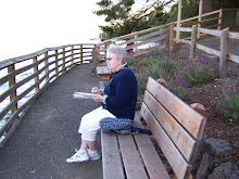
The picture of Cindy sketching (above) is actually the morning of day 4. We “broke camp” from Willard Bay State Park Campground and headed south on I-15. We first checked out the location of the nearby RV site (Cottonwood), and decided we had been at the better location, even without hookups. We left about 9:45am and got to our lodging (Comfort Suites) in Provo at about 11:45am, a distance of about 93 miles. We got gas, stopped at Riteaid, and a grocery store, and prepared for the next round of RV activities. Did a very nice mall (University Mall) and enjoyed a good dinner at Golden Corral, just up the street from our motel. We also walked through a nearby garden that focused on plantings not so demanding for water. The garden is presented and maintained by the local water authority.

Up to today, the weather has been cool during the day, and cold at night. No more. It was up to 860 and bright sun this afternoon. Means we’ll do our trail walks in the mornings and late afternoons from here on out. On to Arches!
